Menne: Unterschied zwischen den Versionen
(/* Characterization of the Menne from Meyer 2003 MEYER, A., E.I. MEYER & C. MEYER 2003. Lotic communities of two small temporary karstic stream systems (East Westphalia, Germany) along a longitudinal gradient of hydrological intermittency. Limnologica…) |
(/* Characterization of the Menne from Meyer 2003 MEYER, A., E.I. MEYER & C. MEYER 2003. Lotic communities of two small temporary karstic stream systems (East Westphalia, Germany) along a longitudinal gradient of hydrological intermittency. Limnologica…) |
||
| Zeile 11: | Zeile 11: | ||
== Characterization of the Menne from Meyer 2003 <ref>MEYER, A., E.I. MEYER & C. MEYER 2003. Lotic communities of two small temporary karstic stream systems (East Westphalia, Germany) along a longitudinal gradient of hydrological intermittency. Limnologica 33 (4): 271–279. </ref>== | == Characterization of the Menne from Meyer 2003 <ref>MEYER, A., E.I. MEYER & C. MEYER 2003. Lotic communities of two small temporary karstic stream systems (East Westphalia, Germany) along a longitudinal gradient of hydrological intermittency. Limnologica 33 (4): 271–279. </ref>== | ||
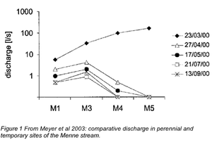
[[Datei:Menne discharge.png|mini|Modified from Meyer et al 2003]] | |||
ELWAS GewässerId: 2782852 (keine Info) | ELWAS GewässerId: 2782852 (keine Info) | ||
Catchment area = 7.5 km2<br> | Catchment area = 7.5 km2<br> | ||
Length = 7 km<br> | |||
Length = 7 km | Widths = 0.5 - 2 m<br> | ||
Permanent spring and springbrook = 150 m<br> | |||
Widths = 0.5 - 2 m | Elevation = 195 - 245 m<br> | ||
Stream slope = 1.7 - 2.0 %<br> | |||
Permanent spring and springbrook = 150 m | Conductivity = 500 - 630 μS/cm<br> | ||
pH = 7.0 - 7.4<br> | |||
Elevation = 195 - 245 m | water hardness = 15.7 - 16.2 ºdH<br> | ||
Substrate: limestone rocks, coarse gravel and cobbles<br> | |||
Stream slope = 1.7 - 2.0 % | Debris: high before next flood event<br> | ||
Conductivity = 500 - 630 μS/cm | |||
pH = 7.0 - 7.4 | |||
water hardness = 15.7 - 16.2 ºdH | |||
Substrate: limestone rocks, coarse gravel and cobbles | |||
Debris: high before next flood event | |||
== Sampling sites == | == Sampling sites == | ||
Version vom 14. Mai 2020, 11:07 Uhr
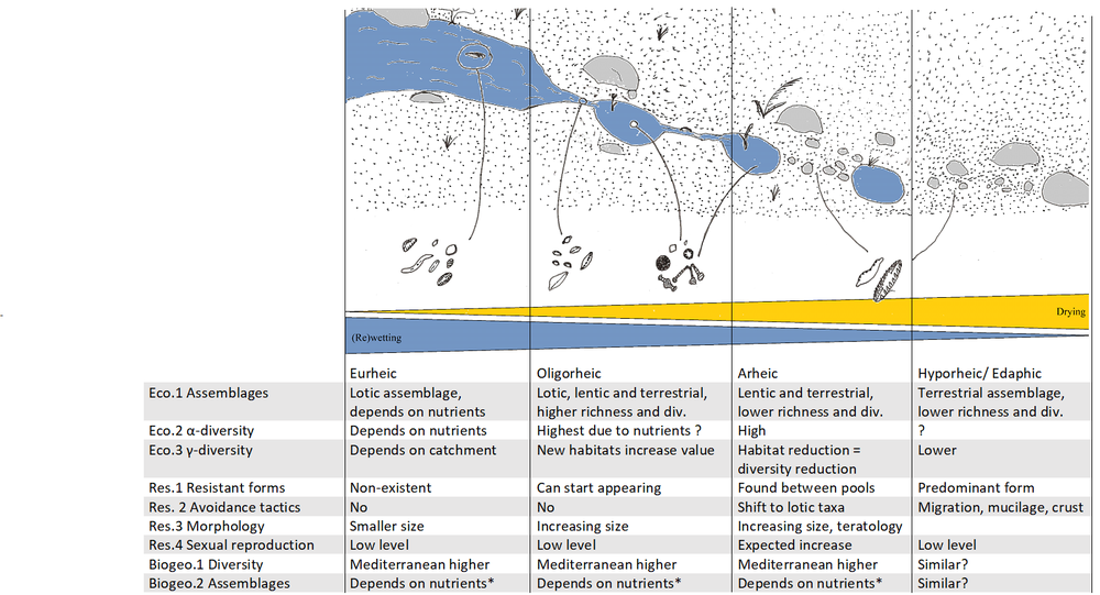
Hypotheses regarding ecology and biogeography of diatoms in temporary streams in each aquatic state.
The Lippe - Alme System
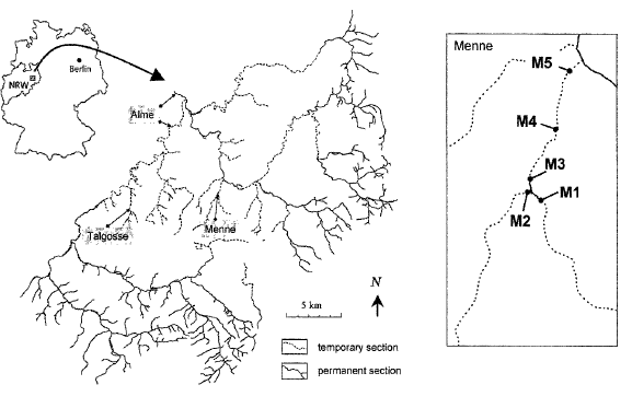
The Menne is a tributary of the Altenau, which is a tributary to the Alme, the Lippe tributary which flows into the Rhine.
The Menne was studied by Meyer et al. in 2003, looking into the effect of karstic drought on macroinvertebrates. The aim of our study is to characterize the diatom communities in ephemeral and inundated locations along this stream.
Characterization of the Menne from Meyer 2003 <ref>MEYER, A., E.I. MEYER & C. MEYER 2003. Lotic communities of two small temporary karstic stream systems (East Westphalia, Germany) along a longitudinal gradient of hydrological intermittency. Limnologica 33 (4): 271–279. </ref>
ELWAS GewässerId: 2782852 (keine Info)
Catchment area = 7.5 km2
Length = 7 km
Widths = 0.5 - 2 m
Permanent spring and springbrook = 150 m
Elevation = 195 - 245 m
Stream slope = 1.7 - 2.0 %
Conductivity = 500 - 630 μS/cm
pH = 7.0 - 7.4
water hardness = 15.7 - 16.2 ºdH
Substrate: limestone rocks, coarse gravel and cobbles
Debris: high before next flood event
Sampling sites
| Sampling site | Lat | Long | Elevation [m] |
|---|---|---|---|
| M1 | 51.589308 N | 8.755923 E | 245 |
| M2 | 51.589975 N | 8.754721 E | 244 |
| M3 | 51.590694 N | 8.754786 E | 231 |
| M4 | 51.597248 N | 8.760392 E | 208 |
| M5 | 51.602579 N | 8.762742 E | 195 |
Perennial springbrook: M1, M3 Perennial spring: M2
Temporary stream section: M4, M5


